


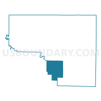
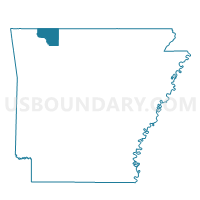
Omega Voting District, Carroll County, Arkansas
About
Outline

Summary
| Unique Area Identifier | 526075 |
| Name | Omega Voting District |
| County | Carroll County |
| State | Arkansas |
| Area (square miles) | 34.75 |
| Land Area (square miles) | 34.75 |
| Water Area (square miles) | 0.00 |
| % of Land Area | 100.00 |
| % of Water Area | 0.00 |
| Latitude of the Internal Point | 36.21340060 |
| Longtitude of the Internal Point | -93.56427010 |
Maps

Graphs
Select a template below for downloading or customizing gragh for Omega Voting District, Carroll County, Arkansas


Neighbors
Neighoring Voting District (by Name) Neighboring Voting District on the Map
- Alabam Voting District, Madison County, AR
- Cabanal Voting District, Carroll County, AR
- Dryfork Voting District, Carroll County, AR
- Marble Voting District, Madison County, AR
- NW & SW Prairie Voting District, Carroll County, AR
- Piney Voting District, Carroll County, AR
Top 10 Neighboring County Subdivision (by Population) Neighboring County Subdivision on the Map
- Prairie township, Carroll County, AR (7,555)
- Alabam township, Madison County, AR (1,261)
- Omega township, Carroll County, AR (489)
- Cabanal township, Carroll County, AR (381)
- Marble township, Madison County, AR (318)
- Dry Fork township, Carroll County, AR (292)
- Piney township, Carroll County, AR (226)
Top 10 Neighboring Unified School District (by Population) Neighboring Unified School District on the Map
- Huntsville School District, AR (14,572)
- Berryville Public Schools, AR (10,893)
- Eureka Springs School District, AR (7,998)
- Jasper School District, AR (5,912)